12 features that save site managers time and stress every day
09.05.2025

Imagine your site team can carry out measurements, stake-outs and documentation on its own, fast and precisely – without external surveyors or expensive special equipment. That is exactly what SitePlan makes possible.
Proven in over 5,000 civil engineering projects, the SitePlan app transforms analog, paper-based processes into a digital workflow that even non-surveyors can use immediately.
Welcome to the future of construction site documentation:
Analog site processes in the digital age – an expensive obstacle
Despite technological progress, many civil engineering projects still run on paper-based processes that are not only inefficient but also error-prone. Site managers, foremen and billing technicians face practical challenges every day that digital solutions could have simplified long ago.
1. Paper plans as a constant brake on site
On site, large-format paper plans are extremely impractical. They constantly have to be unfolded, read and interpreted – a constant search for orientation.
2. Laborious manual surveying
Manholes, service connections or utility lines often have to be staked out with string and tape measure. Anyone who needs accuracy has to hire expensive external surveyors – an avoidable cost factor.
3. Lost knowledge through analog documentation
Local conditions are usually surveyed by hand and documented on paper plans. These plans then often disappear into drawers – which makes planning follow-up projects massively harder.
4. No link between photos and position
Site photos are rarely georeferenced. As a result, important proof of work performed is often missing at billing, for example for difficult ground conditions.
5. Field measurements: laborious, time-consuming, error-prone
Asphalt areas or other components are still frequently recorded with a measuring wheel – noted on clipboards. A method from the past that wastes valuable working time.
Conclusion: The consequences of analog processes are high costs, laborious rework and a lack of transparency. Those who digitize now secure a clear competitive advantage – with more efficient workflows, more precise data and better collaboration between site and office.
The solution: SitePlan
With SitePlan you digitize your surveying and geo-documentation – simple, fast and accurate.
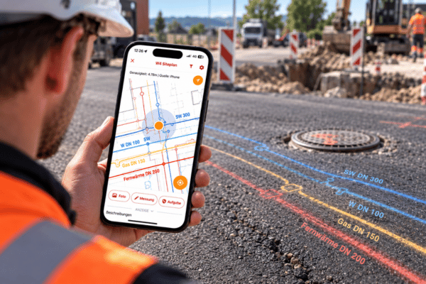
- Digital plans are georeferenced and used on the smartphone – just like Google Maps.
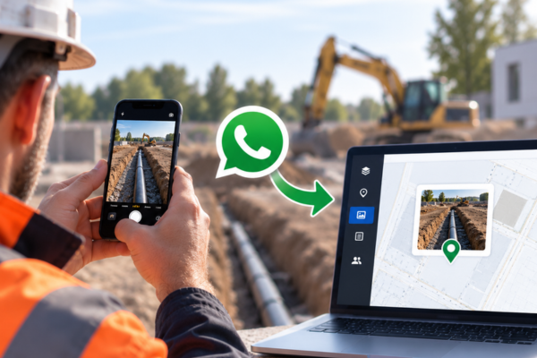
- Photos are automatically linked to location data.
- GNSS antenna enables centimeter-accurate measurements and stake-out.
- Export functions for PDF, TXT or DXF reports make handovers to clients easier.
Particularly important: Even foremen and site managers without surveying training can work productively and safely with the app thanks to its simple operation.
Four use cases from the field
1. Utility markings
With SitePlan and a GNSS antenna, utility lines are marked precisely from PDF plans in just a few minutes – without tape measure and string
- 94 % time savings compared to the classic method
- 70–80 % fewer utility strikes
- Particularly helpful with utility plans, e.g. from telecommunications providers
“One look at the app shows me immediately where the existing utilities run. That saves an enormous amount of time.” – Reinhold S., Foreman, PORR
2. Stake-out
Service connections, manholes, routes or clearing areas can be staked out independently with SitePlan – external surveyors are usually no longer needed.
- Up to 80% savings on surveying costs
- Import of coordinate lists possible
- No more waiting and coordination times
“My foreman can get started right away. Especially with 1,100m of drainage pipes, a real game changer.” – Maximilian R., Site Manager, STRABAG
3. cm-accurate as-built survey
More and more clients demand precise documentation as a separate bill item. With SitePlan this requirement is handled in-house – at no extra cost.
- Capture utility routes at the push of a button
- Georeferenced photos including coordinates
- Data export for CAD and GIS programs with just a few clicks
4. Digital field measurements
Asphalt areas and other geometries can be captured in seconds with the GNSS antenna – directly on site, centimeter-accurate, automatically synchronized.
- 5x faster than with measuring wheel and clipboard
- Live sync in the office + PDF measurement report immediately available without post-processing
- Structure developed together with Deutsche Bahn – audit-proof & verifiable
“I’m always up to date in the office – and have the basis for billing right there.” – Thomas P., Quantity Surveyor, STRABAG
Areas of application and projects
SitePlan is used flexibly and across sectors – from small construction companies to large infrastructure projects. Typical areas of application are:
- Utility, earthworks, water and road construction
Ideal for service connections, excavation work, asphalting and sewer construction. - Railway construction
Used at Deutsche Bahn and by renowned railway construction companies such as Rhomberg Sersa Rail Group or Rail Power Systems for documentation, measurement and stake-out. - Used by small to large construction companies
From regional civil engineering contractors to national players such as STRABAG, PORR, DB and many more.
Examples from site
Rehabilitation of ABA & WVA Spittal an der Drau (Austria)
STRABAG on behalf of the municipality of Spittal
Use: Digital measurements, utility locating and GPS photo documentation for documenting and billing several kilometers of utility construction.
Broadband rollout Deutsche Bahn (Germany)
DB Bahnbau Gruppe on behalf of DB InfraGo
Use: Route-wide GPS photo documentation and as-built survey along thousands of kilometers of railway line for route assessment and planning.
Flood protection Schärding (Austria)
ARGE PORR–SWIETELSKY on behalf of the city of Schärding
Use: Digital stake-out of sheet pile walls, embankments and utility lines as well as georeferenced as-built survey for end-to-end construction documentation.
Your advantages at a glance
✅ with georeferenced photo documentation, no information about billable work performed and variations is lost at billing anymore
✅ existing utilities are marked 10x faster and 70-80% of utility strikes are avoided
✅ approx. 80% of external surveying costs can be saved.
✅ field measurements are created more than 5x faster with SitePlan.
✅ the cm-accurate as-built survey brings a major competitive and price advantage
✅ site and office connected: access to all data at any time from any device
Get personal advice
Want to know how SitePlan can be used specifically in your company – or start a pilot project right away?
Then book a no-obligation consultation with our team now:
Or test the SitePlan app for free:
We’ll show you how easy getting started with digital site documentation really is – individually, practical and with no obligation.